
Celebrating National Surveyors Week at Matthews | DCCM
Written by: Kristy Buttermore
At Matthews | DCCM, we are proud to celebrate National Surveyors Week, an annual event dedicated to recognizing the indispensable role surveyors play in shaping our communities. Established by the National Society of Professional Surveyors (NSPS), this week serves as an opportunity to highlight the work of surveying professionals, whose expertise ensures the accuracy and success of projects that impact our daily lives.
To mark the occasion, we’re bringing you an inside look at the Matthews | DCCM Surveying Team. In this article, we’ve gathered insights through a series of interviews with our talented surveyors. Each of them shares their experiences, the challenges they face, and what they find most rewarding about their work.
Join us as we celebrate their contributions to the field of surveying and explore how their work plays a crucial role in the projects that shape Northeast Florida!
What inspired you to become a surveyor?
John: When I got my first job surveying as a rodman, I had no clue what surveying was. Once I got into the swing of things, I realized that this was a field I enjoy working in and have stuck with it ever since.
Trevor: I liked the idea of working with technology to map out the world, there is a nice blend of science and creative thinking in the field of survey drafting.
Jeremy: After I lost my career with the phone company, I started taking classes at FSCJ, took a geography course, and was told by my professor I need to look into Geomatics at UF. He was right, I never even knew this was a job before that.
Larry: I didn’t have any inspiration other than needing a steady job in my 20s.
What do you enjoy most about being a surveyor?
John: The thing I enjoy most about surveying is being outdoors and the constant change in scenery. We get to see a lot of cool and interesting places in my opinion.
Trevor: I enjoy the problem-solving aspect of surveying as well as the opportunity to contribute to important projects.
Jeremy: I enjoy the map making process and research into historical records. The hybrid work it requires of having large field element and office element.
Larry: Being part of a community of professionals that have heritage back to the founding of the U.S. and that today we can still retrace their maps and history.
What’s one misconception people have about surveying?
John: I don’t think most people have much understanding in general as to what surveying is and what purpose it serves. Besides that, I’d say the biggest misconception about surveying (from the field perspective) is that people don’t realize how much work and thought goes into getting the survey from the field to the computer in an accurate, timely manner.
Trevor: People think surveying is just about measuring land, but it’s much more complex. It involves combining advanced technology, data analysis, and geospatial principles.
Jeremy: This is people on the side of road looking through equipment and shooting lasers at prisms. A few favorite lines I have heard from some after telling them what I did, “people go to school for that” or “that sounds fun, but it requires math, so I’m out”
Larry: That we are taking pictures of you!
What’s one of the most interesting projects you’ve worked on?
John: It’s really impossible for me to pick just one. There are a wide variety of tasks I’ve performed in many different places that have all brought about unique challenges/circumstances and they have all taught me different lessons.
Trevor: The most interesting projects are mapping historical sites. The challenge of interpreting historical maps with updated field data can be very rewarding.
Jeremy: The Indigo Branch survey we did here was very interesting.
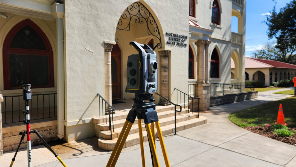
Larry: Sisters of St. Joseph Historic St. Augustine
How does surveying play a crucial role in civil engineering and land development?
John: Surveying is involved every step of the way. From the initial boundary/topo so that you know what the specs are on the land that will be developed to the planning and layout of the underground utilities, drainage, roads, buildings, etc. to ensure proper horizontal and vertical placement of structures to the as-builts once a construction project has been completed to ensure everything has been built within proper spec. There’s much more but this is a brief summary.
Trevor: Surveying is the foundation of civil engineering and land development. It provides the precise data needed for planning, construction, and ensuring the accuracy and efficiency of infrastructure projects.
Jeremy: Surveying is the first step in any civil engineering project. It is the basis of the work. Then at every step along the way, the surveyor is the go between the actual construction of the project and the engineered plans during the staking and as-built process. Checking and sometimes correcting any mistakes made on the plans or in the field.
Larry: Surveyors are first in last out. We provide critical data for the conceptual plans through to as-builts.
What’s the most rewarding part of your job?
John: Probably seeing the final outcome of the work I’ve done whether it be a final map of a boundary/topo or a newly constructed parking lot, building, sidewalk, etc. that I staked out previously and knowing that I played an important role in that.
Trevor: The most rewarding part is seeing the tangible results of our contribution to a project, whether it’s a completed building, a new road, or a preserved natural area.
Jeremy: Completing a project and watching my hard work live on in the completion of the project.
What advancements in technology have had the biggest impact on the field of surveying?
John: I would say that GPS and Total Stations along with the data collectors they are used with are the main things that come to my mind when thinking about what advancements in technology have had the biggest impact on the field of surveying. They allow one person to do many tasks that would otherwise require an entire crew and will also produce much more accurate results exponentially faster than methods of the past. They have revolutionized the art of surveying in my opinion.
Trevor: Advancements like GPS and GIS have significantly impacted surveying. These tools allow for more detailed and accurate mapping, enabling surveyors to capture data in ways that were previously impossible.
Jeremy: Real Time GPS and how accurate it is. LIDAR technology and its ability to cut through thick vegetation and even through water.
Larry: The lower cost of entry to LiDAR scanners is going to continue to make traditional topo work extinct.
What’s the most unusual or surprising thing you’ve come across while surveying?
John: This is another one where I couldn’t pick just one thing. One that stands out is a bee hive in Oak Hill that was about the same size as me. A cow took my gps base down one time in Daytona after getting tripped up in the antenna extension. Also had a base station stolen in Kissimmee so that was an experience. Lots of snakes, gators, crazy bugs, etc. and that’s what I love so much about what I do.
Trevor: I am always pleased to come across a particularly well drawn historic map when doing monumentation research for a job.
Jeremy: There was survey I did in the field after the hurricane in 2017 in south Ponte Vedra beach. The beach eroded under a house on the beach. And the bottom of the house had fallen through. There were kitchen appliances, beds, dressers, a tv, and clothes all the over the beach.
What advice would you give to someone considering a career in surveying?
John: Sunscreen
Trevor: Learning how to use the tools in the field and directly using the data in the office is an invaluable way to learn the skills of the trade.
Jeremy: In the field, To prepare for everything, no two jobs are the same. Expect things to be hot, cold, rainy, muddy, bugs and a whole lot of weather. At the end of the day this job is adventure every day. It’s a completely different job in office. This is what makes this field so unique, you have to know how to wear many different hats.
Larry: Get in while you can as the old institutional knowledge is aging out of the industry. Also, go to school immediately.
If you could survey anywhere in the world, where would it be and why?
John: I think it would be interesting to survey in Australia just because it’s somewhere I find interesting and would like to visit someday.
Trevor: I would love to survey a remote tropical island. The unique ecosystems and geographical features, such as coral reefs and volcanic formations, would present exciting challenges. Additionally, contributing to the conservation and sustainable development of such a pristine environment would be incredibly rewarding.
Jeremy: Scotland, I have learned to hate the sun.
Larry: Arctic regions
Need Reliable Surveying Services? We’ve Got You Covered!
Whether you’re planning a new project or need precise surveying services, Matthews | DCCM is here to help. Our experienced team is ready to provide reliable and accurate survey data to ensure the success of your next endeavor. Contact us today to learn more about our surveying services and how we can support your project!
additional articles
-
October 10, 2025
International Day for Disaster Risk Reduction 2025: Fund Resilience, Not Disasters
-
October 2, 2025
October Is National Community Planning Month
-
September 11, 2025
Celebrating Growth from Within: Brynna Bartlett Promoted to Project Manager
-
August 15, 2025
Back to School Drive Success: Supporting Local Youth at Port in the Storm
-
August 6, 2025
Celebrating Professional Engineers Day